Fort Dufferin
Highway 75, 3 Miles North Of Emerson, Emerson, Manitoba
DESCRIPTION OF HISTORIC PLACE
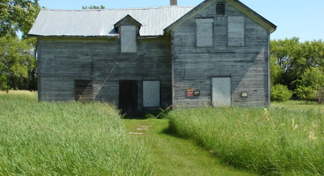
Located in a rural area north of the town of Emerson, Manitoba, on the west bank of the Red River, Fort Dufferin National Historic Site of Canada consists of the remains of a complex of buildings that was used as the main camp for the North American Boundary Commission (NABC) from 1872. It was then used by the North West Mounted Police (NWMP) in preparing for the March West and as a police post during the winter of 1875. Official recognition refers to the remains of the core complex of buildings, four standing buildings (referred to as the mess kitchen, storage building, stable and latrine), at least twelve depressions (former cellars, pits and semi-subterranean buildings) and landscape features.
HERITAGE VALUE
Fort Dufferin was designated a national historic site of Canada in 1999 because:
- it supported the assertion of Canada’s sovereignty over Manitoba and the North-West Territories between 1872 and 1879;
- it was a pivotal location of operation for the British-Canadian contingent of the North American Boundary Commission in its work to define and mark the 49th Parallel from the fall of 1872 to the winter of 1874;
- it was the site where the newly formed North-West Mounted Police assembled and on 8 July 1874, set out on its famous “March West”; and,
- it functioned as Manitoba’s southern border immigration station from 1875 to 1879, receiving more than 18,600 people of diverse origins.
Beginning in 1872, Fort Dufferin served as the base of field operations for the North American Boundary Commission, which worked for the next two years to define and mark the 49th Parallel. Subsequently, the North West Mounted Police used Fort Dufferin on two separate occasions, first in 1874 as the marshalling area for the “March West” and then in the winter of 1874-1875 as the headquarters of ‘D’ Division. Between 1875 and 1879, Fort Dufferin served as a port of entry to Manitoba and gateway to western Canada. Fort Dufferin’s role as immigration station lasted only as long as boats on the Red River were the main mode of transport for immigrants to Manitoba. The property subsequently served as a livestock quarantine station before being sold to private owners, and then finally to the Province of Manitoba.
Sources: Historic Sites and Monuments Board of Canada, Minutes, December 2005; Commemorative Integrity Statement, January 2007.
CHARACTER-DEFINING ELEMENTS
Key elements contributing to the heritage value of this site include:
- its location along the bank of the Red River, near Emerson Manitoba;
- its relatively isolated setting within a meadow in the riparian forest along the Red River;
- the original, basic 1872 structure of the Mess Kitchen on its mudsills and its original frame construction and finishes under layers of later material, situated in its original location;
- the standing storage building, stable and latrine which bear materials and framing indicative of North American Boundary Commission construction and have partial dimensions approximating historic NABC buildings;
- the above and below ground evidence of archaeological remains relating to the 1874-1879 period;
- the integrity of any surviving or as yet unidentified archaeological remains which may be found within the site in their original placement and extent;
- the viewscapes to and from the Red River and surrounding fields.
Photo Credit: http://www.bridgmancollaborative.ca/fort-dufferin.html
Text Credit: DESCRIPTION DU LIEU PATRIMONIAL
Situé dans une zone rurale au nord de la ville d’Emerson, au Manitoba, sur la rive ouest de la rivière Rouge, le lieu historique national du Canada du Fort-Dufferin est composé des ruines du complexe central construit pour la Commission des frontières nord-américaines (CFNA) à partir de 1872. Il a ensuite été utilisé par la Police à cheval du Nord-Ouest (P.C.N.-O) en préparation pour la Marche vers l’Ouest et il a aussi servi de poste de police au cours de l’hiver 1875. La reconnaissance officielle fait référence aux ruines du complexe central, aux quatre bâtiments existants (appelés cuisine du réfectoire, entrepôt, étable et latrine), à au moins douze dépressions (anciennes caves, fosses et bâtiments semi-souterrains) et à des éléments paysagers.
VALEUR PATRIMONIALE
Le fort Dufferin fut désigné lieu historique national du Canada en 1999 pour les raisons suivantes :
- le fort Dufferin a servi à affirmer la souveraineté du Canada sur le Manitoba et les Territoires du Nord-Ouest entre 1872 et 1879;
- il a été d'une importance cruciale comme base d'opération du contingent britanno-canadien de la Commission des frontières nord-américaines ayant délimité et aborné la frontière du 49e parallèle de l'automne 1872 à l'hiver 1874;
- il a servi de lieu de rassemblement à la toute nouvelle Police à cheval du Nord-Ouest avant qu'elle n'entreprenne, le 8 juillet 1874, sa fameuse « marche vers l'Ouest »;
- il a tenu lieu de station d'immigration à la frontière sud du Manitoba de 1875 à 1879, années au cours desquelles il a accueilli plus de 18 600 personnes des origines les plus diverses.
Dès 1872, le fort Dufferin a servi de base d’opérations sur le terrain à la Commission des frontières nord-américaines qui a travaillé au cours des deux années suivantes à définir et à baliser le 49e parallèle. Par la suite, la Police à cheval du Nord-Ouest a utilisé le fort Dufferin à deux reprises, la première fois en 1874 comme poste de maréchal de la Marche vers l’Ouest, puis à l’hiver 1874-1875 comme quartier général de la Division « D ». Entre 1875 et 1879, le fort Dufferin a servi de port d’entrée au Manitoba et de portail vers l’ouest canadien. Le rôle du fort Dufferin en tant que poste d’immigration n’a duré que le temps où les bateaux de la rivière Rouge étaient le principal mode de transport des immigrants vers le Manitoba. La propriété a ensuite servi d’aire de quarantaine pour le bétail, avant d’être cédée à des propriétaires privés, puis par la suite acquise par la province du Manitoba.
Sources : Commission des lieux et monuments historiques du Canada, Procès-verbal, décembre 2005; Énoncé d’intégrité commémorative, janvier 2007.
ÉLÉMENTS CARACTÉRISTIQUES
Les principaux éléments qui contribuent à la valeur patrimoniale de ce lieu sont les suivants :
- son emplacement sur la berge de la rivière Rouge, près d’Emerson, au Manitoba;
- son emplacement relativement isolée dans un pré, en pleine forêt riveraine le long de la rivière Rouge;
- la structure de base originale de 1872 de la cuisine du réfectoire sur ses assises et la structure et les finis originaux sous des couches subséquentes de matériaux, situés à leur emplacement original;
- l’entrepôt, l’écurie et les latrines existants, dont les matériaux et la structure indiquent leur construction par la Commission des frontières nord-américaines et dont les dimensions partielles sont approximativement celles des bâtiments de la CFNA;
- les traces au-dessus et au-dessous du niveau du sol de ruines archéologiques datant de la période 1874-1879;
- l’intégrité des traces archéologiques connues ou à découvrir sur le site, leurs emplacements et dans leurs étendues d’origine;
- l'intégrité des vestiges archéologiques qui subsistent ou qui n'ont pas encore été mis au jour, mais qui pourraient l'être à leur emplacement et dans leur état d'origine;
- les vues de et vers la rivière Rouge et les champs environnants.